Exploring Georgia’s 16 Historic Covered Bridges
JUMP TO: North Georgia Bridges | Central Georgia Bridges | South Georgia Bridges
When Tina and I first started Georgia Road Trippin’ earlier this year, one of the first goals I set for us was to eventually visit all of Georgia’s historic covered bridges. There are 16 of these architectural marvels scattered across the Peach State that I’m aware of, and our mission is to delve into the history, beauty, and unique stories behind each bridge.
To-date, we’ve visited three, all discussed on our blog:
- Auchumpkee Creek Covered Bridge
- Big Red Oak Creek Covered Bridge
- Stovall Mill Covered Bridge
In this comprehensive guide, we’ll discuss insights and practical tips to help fellow enthusiasts and travelers appreciate these charming structures that are not just feats of engineering but also windows into Georgia’s past.
So if you’re out to see one, a few, or all of Georgia’s covered bridges, the information provided here should help you plan your adventures. We’ve broke it down by bridges found in North, Central, and South Georgia. Maybe we’ll see you along the way!
North Georgia Covered Bridges

Quick Look
- Location: Smyrna, Cobb County
- Other names: Nickajack Creek Covered Bridge
- Year Built: 1872
- Builder: Robert Daniell & Martin L. Ruff
- Length: 131.7 feet (40.1 m)
- Crosses: Nickajack Creek
- Design: Queen-rod
- Historical Notes: A regal structure listed on the National Register of Historic Places, Concord Covered Bridge spans both time and the serene Nickajack Creek.
Fun Facts
The Concord Covered Bridge is a central feature of the Concord Covered Bridge Historic Area, which includes an old railroad bed now part of the PATH Foundation’s Silver Comet Trail, a dedicated bike and pedestrian path.
This historic area is also notable for its Civil War heritage, with remnants of Ruff’s Mill and ruins of a dam and grist mill still visible upstream of the bridge, while the miller’s house remains occupied.
Historically, the Concord bridge had the highest traffic count among Georgia’s covered bridges, though this has decreased since the completion of the East-West connector.
Quick Look
- Location: Watkinsville, Oconee County
- Other names: Rose Creek Bridge
- Year Built: 1897
- Builder: Nathaniel Richardson
- Length: 100 feet (30 m)
- Crosses: Rose Creek
- Design: Town lattice
Fun Facts
Constructed in 1897 in the town lattice style, the bridge originally spanned Calls Creek on the Watkinsville-Athens Road. John Chandler of Watkinsville moved it by wagon to its present location in 1924.
Recently restored, it is one of only a few bridges in Georgia that still carries traffic without help from underlying steel beams.
Local community support is in evidence at the site with the Watkinsville Garden Club’s planting at the East end of the bridge. A neighbor decorates the bridge with Christmas lights every December.
Quick Look
- Location: Maysville, Jackson County
- Year Built: 1884 (rebuilt in 2002 after a fire)
- Length: 127 feet (39 m)
- Crosses: North Oconee River
- Design: Town lattice
Fun Facts
In 1869, the Jackson County Court of Ordinary commissioned the construction of a covered bridge across the river at Hurricane Shoals. By 1870, the 127-foot-long bridge, featuring the popular “town lattice” truss design, was operational near Georgia 82 Spur, south of Maysville and north of Jefferson.
Tragically, this historic Jackson County bridge burned down on May 31, 1972, leaving only 21 covered bridges in Georgia. A photograph taken by Mr. Whitworth Brown in 1969, later reproduced by artist Miss Jean Flaniger in 1979, captured its former glory.
In 1994, the Tumbling Waters Society sought federal funding through the Intermodal Surface Transportation Enhancement Act (ISTEA) to rebuild the bridge and create a historical village at the Park. Despite initial rejection, the grant was eventually secured thanks to the efforts of Steve Reynolds and others, paving the way for the bridge’s reconstruction.
Quick Look
- Location: Gainesville, Hall County
- Other names: Blind Susie Bridge, Hyder Bridge
- Year Built: 1915
- Builder: W. M. Thomas
- Length: 34 feet (10 m)
- Crosses: Grove Creek
- Design: King post
Fun Facts
The bridge near Lula, known as Georgia’s smallest covered bridge and one of the smallest in the United States, sits on an abandoned golf course just south of the town. Visible from Antioch Road, this bridge is on private property, surrounded by ‘No Trespassing’ signs, making a visit inadvisable despite the seemingly inviting picnic tables and signage.
Operational until 1969, it was replaced by a nearby concrete bridge. In 1975, the bridge was dismantled, rebuilt on the banks, and then lifted back onto its original foundations by a crane. Commonly mistaken as the Blind Susie Bridge, this bridge is actually different from the real Blind Susie Bridge, which was located on the other side of Banks County and is known for its namesake, a local woman famous for selling moonshine.
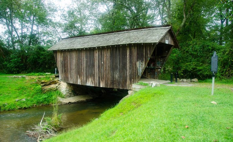
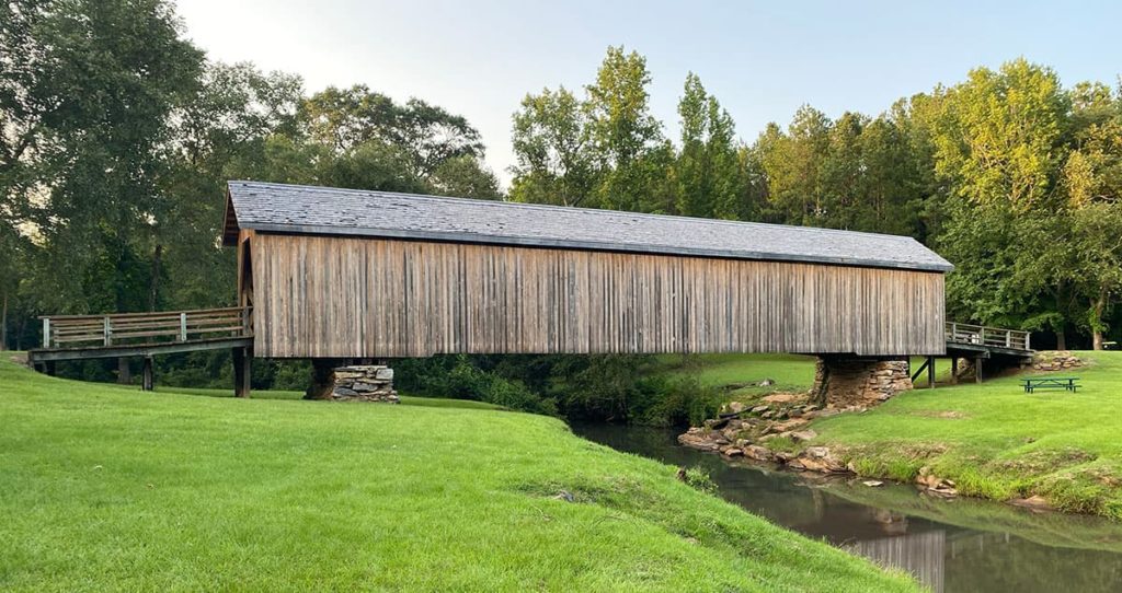
Quick Look
- Location: Helen, White County
- Other names: Helen Bridge, Sautee Bridge, Nacoochee Bridge, Chickamauga Bridge
- Year Built: 1895
- Builder: Will Pardue
- Length: 36.8 feet (11.2 m)
- Crosses: Chickamauga Creek
- Design: Queen post
Fun Facts
Stovall Mill Bridge, located in a historically rich area of White County, Georgia, crosses Chickamauga Creek, distinct from the creek of the same name in northwest Georgia. An earlier bridge at this site was lost to a flood in the early 1890s.
The bridge is named after Fred Stovall, Sr., who long operated a mill complex, including a gristmill, sawmill, and shingle mill, all now gone except for the dam’s remnants. Nearby, the Stovall family’s historic home has been transformed into a Bed and Breakfast and restaurant.
A short drive from local attractions, the bridge gained fame in the 1950s movie “I’d Climb the Highest Mountain.”
Recent inspections revealed extensive termite damage, necessitating significant wood replacement and repairs with epoxy, particularly challenging due to the bridge’s queen post truss design.
Read about our visit to Stovall Mill Covered Bridge.
Quick Look
- Location: Stone Mountain Park, DeKalb County
- Other names: College Avenue Covered Bridge, Effie’s Bridge
- Year Built: 1891
- Builder: Washington W. King
- Length: 151 feet (46 m)
- Crosses: Stone Mountain Park Lake
- Design: Town lattice
Fun Facts
Originally spanning the Oconee River in Clarke County and known as the College Avenue Bridge (or Effie’s Bridge, named after a nearby bordello), this bridge was relocated to Stone Mountain Park in 1965 for $18,000 after being sold for a dollar.
It now serves as an access point to the Indian Island picnic area. Stone Mountain Park, where the bridge currently resides, offers a variety of attractions including a riverboat, a skylift to the mountain’s summit, a railroad, a museum, and a zoo, making it a popular destination for visitors.
Central Georgia Covered Bridges
Quick Look
- Location: Thomaston, Upson County
- Coordinates: 32.7556°N, 84.2302°W
- Other names: Hootenville Bridge
- Year Built: 1892 (rebuilt in 1997)
- Builder: W. Alford/Dr. J. Harding
- Truss: Town lattice
- Length: 96 feet
- Crosses: Auchumpkee Creek
- Design: Town lattice
- Historical Notes: Listed on the National Register of Historic Places, Auchumpkee Creek Covered Bridge stands as a testament to resilience after its 1997 reconstruction.
Fun Facts
The Auchumpkee Creek Covered Bridge, originally destroyed in the 1994 floods, underwent a remarkable restoration thanks to a combined effort of FEMA, which contributed $166,000, and local fundraising led by Bobby C. Smith, raising over $42,000.
Reconstructed by Arnold Graton of New Hampshire using traditional methods, including wooden pegs, the bridge was impressively pulled into place by a team of horses on July 3, 1997, a sight not seen in Georgia for decades.
After positioning the bridge over the creek on temporary supports, it was secured on elevated stone abutments to protect against future floods.
The restoration was completed with a new roof, weatherboarding, and approaches, culminating in a dedication at Thomaston’s Covered Bridge Arts Festival from October 9-11, 1998
Read about our visit to the Auchumpkee Creek Covered Bridge.
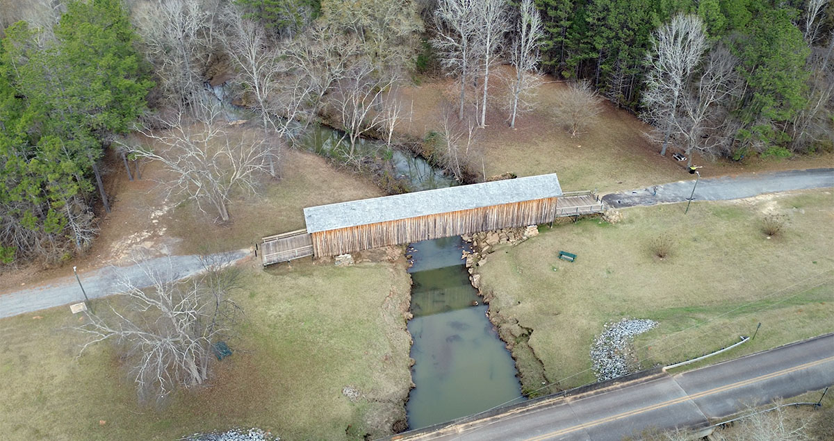
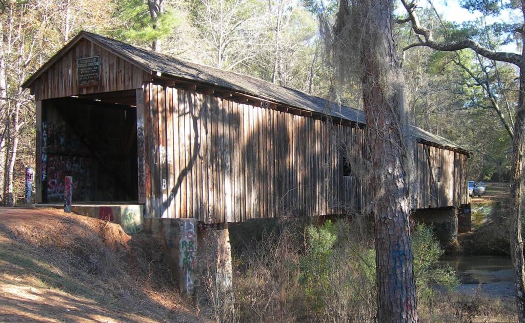
Quick Look
- Location: Woodbury, Meriwether County
- Other names: Imlac Bridge
- Year Built: c. 1840s
- Builder: Believed to be Horace King
- Length: 252.5 feet
- Crosses: Red Oak Creek
- Design: Town lattice
Fun Facts
Often referred to as the longest covered bridge in the state, this bridge has a very long (250 feet) timber-decked approach on one end. So while the bridge itself is the longest wooden bridge, the longest covered section of bridge still belongs to the Watson Mill bridge. However, the unsupported span length of this bridge may well be the longest in the state at 115 feet.
Though Red Oak Creek bridge is Georgia’s oldest remaining covered bridge, it may also be one of its sturdiest. It is open to traffic once again after minor repairs in 1998 and 1999.
Quick Look
- Location: Originally Troup County, but moved to Harris County
- Other names: Neeley Bridge, Harmony Road Bridge, Wehadkee Creek Bridge
- Year Built: 1870
- Builder: Horace King
- Length: 60 feet (originally 173 feet)
- Design: Town lattice
Fun Facts
This bridge was originally built in Troup County by Horace King and his sons. Construction of the West Point Dam would have left the bridge underwater, so Callaway Gardens saved it by moving it onto their property in 1965.
Shortened to fit its new home, the bridge was open to the public for many years near the current location of the John A. Sibley Horticultural Center before being removed. Callaway Gardens says the bridge is in excellent condition in a place “not open to the public.” They eventually plan to incorporate the bridge into future developments and return it to a public area.
Quick Look
- Location: Carnesville, Franklin County
- Other names: Nails Creek Covered Bridge
- Year Built: 1906
- Builder: J.M. ‘Pink’ Hunt
- Length: 132 feet (40 m)
- Crosses: Nails Creek
- Design: Town lattice
Fun Facts
Once a vibrant hub in northeast Georgia, the Cromer’s Mill community, known for its political gatherings and community events, has since been overshadowed by progress and a faster-paced society, leaving the Cromer’s Mill Bridge in a state of neglect and uncertainty.
However, timely restoration efforts that began just before the turn of the millennium have brought the bridge back to a surprisingly good condition. The restoration, completed in September 1999, involved correcting a twist in the structure with new galvanized steel bracing, which, while not historic, is visibly distinct. Additional repairs included replacing part of the top chord and some original bracing.
Recently, local interest in the bridge has been rekindled, evidenced by local media coverage and its influence on the naming of a nearby subdivision.
Quick Look
- Location: Euharlee, Bartow County
- Other names: Lowry Bridge
- Year Built: 1886
- Builder: Washington W. King
- Length: 137.6 feet (41.9 m)
- Crosses: Euharlee Creek
- Design: Town lattice
Fun Facts
The bridge is located adjacent to the ruins of an old mill once owned and operated by Daniel Lowry, who owned most of the land around the bridge. Lowry also allowed the builders to use rock from his land to build the piers of the bridge after high water swept a previous, lower bridge away.
According to Thomas and Edward French in Covered Bridges of Georgia, “He also helped to rebuild the wooden structure. Due to the fact the bridge was swept from its foundation and perhaps came to rest against the mill’s south wall, it may have been salvaged. This could account for the numbering of the web members of the town lattice trusses.”
According to the North Georgia Journal, the previous bridge collapse caused the death of a local man, Mr. Nelson, a mule and a horse. Mr. Nelson’s two young sons emerged from the disaster unscathed. This led to the eventual construction of the present, much sturdier bridge by W.W. King (with perhaps some help from his father though Horace was ill at the time).
Quick Look
- Location: Oglethorpe County
- Other names: Howard Bridge, Big Clouds Creek Bridge
- Year Built: 1905
- Builder: Mr. Hunt?
- Length: 168 feet (51 m)
- Crosses: Big Clouds Creek
- Design: Town lattice
Fun Facts
Situated in a remote area of historic Oglethorpe County, the bridge, once in a state of neglect, has now been fully rehabilitated.
According to “Covered Bridges of Georgia,” a Mr. Hunt, likely J. M. “Pink” Hunt who also built Cromer’s Mill Bridge, is credited as the original builder, with some sources suggesting he collaborated with Washington King.
This bridge was notably ambitious in its design, featuring the longest main span, at 130 feet, of any surviving bridges in the area. However, due to structural reinforcements added over time, including a wooden pier to support its lengthy span, the title of the longest unsupported span has since been passed to the Red Oak Creek bridge.
Quick Look
- Location: Cumming, Forsyth County
- Other names: Pool’s Mill
- Year Built: 1901
- Builder: Bud Gentry
- Length: 94.6 feet (28.8 m)
- Crosses: Settendown Creek
- Design: Town lattice
Fun Facts
Dating back to the 1820s, the construction of this bridge encountered initial setbacks when the original contractor drilled holes incorrectly in the lattice members and abandoned the project.
Bud Gentry completed the work, drilling new holes in the existing members, with the original misplaced holes still visible today.
Before its rehabilitation, the bridge appeared worn but was structurally sound, unlike some others that seemed sturdy but were not. The 1998 rehabilitation included the addition of a new central pier to correct the bridge’s sag and provide support. This involved building a cofferdam, pumping out water for a dry work area, and incrementally jacking up the bridge until it was reasonably straight.
The pier was intentionally given a smooth concrete finish for authenticity, and the weatherboarding was cut straight to conceal any remaining sag. Forsyth County demonstrated its commitment to preserving this local historical site by funding a park with parking, a pavilion, and horseshoe pits through local option sales tax.
South Georgia Covered Bridges
Quick Look
- Location: Blakely, Early County
- Coordinates: 31°18′23″N, 85°04′43″W
- Other names: Bridge at McDonald’s Ford
- Builder: J.W. Baughman
- Year Built: 1891
- Length: 96 feet (29 m)
- Crosses: Coheelee Creek
- Design: Modified Queen Post
- Historical Notes: A proud entry on the National Register of Historic Places, Coheelee Creek Covered Bridge stands as a blend of history and architectural ingenuity.
Fun Facts
The Coheelee Bridge holds the distinction of being the southernmost historic covered bridge in the United States. Its name, as explained by the late Dr. John H. Goff of the University of Georgia, is a testament to the linguistic interplay between Native American dialects and English. Originally named “Big Creek” in the 1820s, the early settlers favored its indigenous name, Coheelee.
This bridge, constructed in 1891, is notable for its unique truss design, incorporating steel rods as tension members, a feature common in the late 19th century and also seen in the Concord Road and Lula Bridges. This design, resembling a queen post or Warren truss, sets the Coheelee Bridge apart in both Georgia and potentially the entire U.S.
Quick Look
- Location: Conyers, Rockdale County
- Other names: Haralson Mill Covered Wooden Bridge
- Year Built: 1997
- Builder: APAC
- Length: 150 feet (46 m)
- Crosses: Mill Rock Creek
- Design: Decorative lattice
Fun Facts
Georgia’s latest covered bridge isn’t historic, but it exemplifies the interest the public still has in covered bridges.
The bridge for this location was originally designed as a prestressed concrete bridge. However, county planners decided to make this bridge a landmark by adding a large wooden superstructure and rock facing to the underlying concrete bridge.
Concerned about the possibility of fire led the county to install cameras, smoke detectors, and a sprinkler system. Total cost of the redesigned bridge: $880,000.
Final Thoughts
These covered bridges, each with its unique design and historical significance, paint a vivid picture of Georgia’s rich architectural and cultural heritage. Exploring these gems offers not only a glimpse into the past but also an appreciation for the craftsmanship that has endured through the ages.
Join Us on Our Journey
Follow along as Tina and I continue to explore these historical treasures. We’ll be sharing our experiences, photos, and tips on our blog and social media. If you’ve visited any of these bridges, we’d love to hear your stories too in the comments section below!